WiGLE task example
In this tutorial we will summarize all of the API concepts chapter and create a task with a schema and a map.
Wrapping WiGLE API with a task
WiGLE API enables you to search WiFi and cellular network devices uploaded by WiGLE users. We will create a task to integrate some of this functionality into Lampyre.
Note
Describing header
from lighthouse import *
from ontology import IP, Domain, IPToDomain
from datetime import datetime

class WirelessNetworks(metaclass=Header):
    display_name = 'Wireless networks'

    SSID = Field('SSID', ValueType.String, system_name='ssid')
    TransId = Field('Trans ID', ValueType.String, system_name='transid')
    Name = Field('Name', ValueType.String, system_name='name')
    NetId = Field('Net ID', ValueType.String, system_name='netid')
    Encryption = Field('Encryption', ValueType.String, system_name='encryption')
    Trilat = Field('Trilat', ValueType.Float, system_name='trilat')
    Trilong = Field('Trilong', ValueType.Float, system_name='trilong')
    QoS = Field('Signal quality', ValueType.Integer, system_name='qos')
    Firsttime = Field('First time', ValueType.Datetime, system_name='firsttime')
    Lasttime = Field('Last time', ValueType.Datetime, system_name='lasttime')
    Lastupdt = Field('Last update', ValueType.Datetime, system_name='lastupdt')
    Housenumber = Field('House number', ValueType.String, system_name='housenumber')
    Road = Field('Road', ValueType.String, system_name='road')
    City = Field('City', ValueType.String, system_name='city')
    Region = Field('Region', ValueType.String, system_name='region')
    Country = Field('Country', ValueType.String, system_name='country')
    Type = Field('Type', ValueType.String, system_name='type')
    Comment = Field('Comment', ValueType.String, system_name='comment')
    WEP = Field('WEP', ValueType.String, system_name='wep')
    Channel = Field('Channel', ValueType.Integer, system_name='channel')
    BcnInterval = Field('Beacon interval', ValueType.Integer, system_name='bcninterval')
    Freenet = Field('Freenet', ValueType.String, system_name='freenet')
    DHCP = Field('DHCP', ValueType.String, system_name='dhcp')
    Paynet = Field('Paynet', ValueType.String, system_name='paynet')
    Userfound = Field('User found', ValueType.Boolean, system_name='userfound')
Creating a Schema
class WirelessStation(metaclass=Object):
    name = 'Wireless station'

    SSID = Attributes.str('SSID')
    MacAddress = Attributes.System.MacAddress
    Name = Attributes.System.Name
    TransId = Attributes.str('Trans ID')
    Encryption = Attributes.str('Encryption')
    QoS = Attributes.int('Signal quality')
    Type = Attributes.str('Type')
    Comment = Attributes.System.Comment
    WEP = Attributes.str('WEP')
    Channel = Attributes.int('Channel')
    BcnInterval = Attributes.int('Beacon interval')
    Freenet = Attributes.str('Freenet')
    DHCP = Attributes.str('DHCP')
    Paynet = Attributes.str('Paynet')
    GeoPoint = Attributes.System.GeoPoint

    Image = Utils.base64string('icons8-router-32.png')

    IdentAttrs = [MacAddress]
    CaptionAttrs = [SSID, MacAddress, Encryption]


class WirelessStationToCity(metaclass=Link):
    name = 'Wifi to city'

    Road = Attribute('Road', ValueType.String)

    CaptionAttrs = [Road]

    Begin = WirelessStation
    End = City
between() creates SchemaLink between two objects on a schema.class WirelessNetworksSchema(metaclass=Schema):
name = 'Networks'
Header = WirelessNetworks
station = SchemaObject(WirelessStation, mapping={
WirelessStation.MacAddress: Header.MacAddress,
WirelessStation.SSID: Header.SSID,
WirelessStation.Name: Header.Name,
WirelessStation.TransId: Header.TransId,
WirelessStation.Encryption: Header.Encryption,
WirelessStation.QoS: Header.QoS,
WirelessStation.Type: Header.Type,
WirelessStation.Comment: Header.Comment,
WirelessStation.WEP: Header.WEP,
WirelessStation.Channel: Header.Channel,
WirelessStation.BcnInterval: Header.BcnInterval,
WirelessStation.Freenet: Header.Freenet,
WirelessStation.DHCP: Header.DHCP,
WirelessStation.Paynet: Header.Paynet,
WirelessStation.GeoPoint: [Header.Trilat, Header.Trilong]
})
city = SchemaObject(City, mapping={City.City: Header.City, City.Country: Header.Country})
country = SchemaObject(Country, mapping={Country.Country: Header.Country})
station_to_city = WirelessStationToCity.between(
station, city,
mapping={WirelessStationToCity.Road: Header.Road},
conditions=[
Condition(Header.MacAddress, Operations.NotEqual, ''),
Condition(Header.City, Operations.NotEqual, '')
]
)
city_to_country = CityToCountry.between(
city, country,
mapping={},
conditions=[
Condition(Header.City, Operations.NotEqual, ''),
Condition(Header.Country, Operations.NotEqual, '')
]
)
Defining a task class
This task will have a GIS macro, enabling a search for routers by selecting a rectangular area on a map.
class WigleWifiSearch(Task):
    def __init__(self):
        super().__init__()
        self.name = 'YOUR_API_NAME'
        self.token = 'YOUR_API_KEY'

    def get_id(self):
        return '7e9b9bde-3c0d-411a-ad32-a3ee992b0224'

    def get_display_name(self):
        return 'WiGLE WiFi search'

    def get_category(self):
        return 'Tutorial tasks'

    def get_description(self):
        return 'Search WiGLE wireless database'

    def get_headers(self):
        return HeaderCollection(
            WirelessNetworks
        )

    def get_enter_params(self):
        return EnterParamCollection(
            EnterParamField('ssid', 'SSID', ValueType.String,
                            description='Include only networks exactly matching the string network name'),
            EnterParamField('fuzzy', 'Fuzzy search', ValueType.Boolean,
                            description='Allow SSID wildcards ‘%’ (any string) and ‘_’ (any character)'),
            EnterParamField('area', 'Area', ValueType.String, geo_json=True)
        )

    def get_weight_function(self):
        return 'ssid'

    def get_schemas(self):
        return SchemaCollection(
            WirelessNetworksSchema
        )

    def get_gis_macros(self):
        return MacroCollection(
            Macro('Search WiFi in WiGLE', mapping_flags=[GisMappingFlags.Instances], schemas=self.get_schemas())
        )
Making a payload
Finally, write a payload for the task in the execute() method. Here we create two additional methods in our task class - one for forming the API request parameters and one for performing the actual request.
def execute(self, enter_params, result_writer, log_writer, temp_directory):
    if not enter_params.ssid and not enter_params.area:
        log_writer.error('SSID or area required')

    request_params = self.create_request_params(enter_params.ssid, enter_params.fuzzy, enter_params.area)
    response = self.perform_search(request_params, log_writer)

    if not response.get('success'):
        log_writer.info('Nothing found')
        return

    total_results = response.get('totalResults')
    log_writer.info(f'Total results: {total_results}')

    results = response.get('results')
    for result in results:
        line = {field: result.get(field.system_name) for field in WirelessNetworks}
        result_writer.write_line(line)

@staticmethod
def create_request_params(ssid: str, fuzzy: bool, area: str) -> Dict[str, str]:
    """
    Creates HTTP request parameters from enter_params
    """
    if area:
        area_angles = json.loads(area, encoding='utf-8')['bbox']
        return {
            'longrange1': area_angles[0],
            'latrange1': area_angles[1],
            'longrange2': area_angles[2],
            'latrange2': area_angles[3],
            'variance': '0.001'
        }

    return {'ssid': ssid} if not fuzzy else {'ssidlike': ssid}

def perform_search(self, params: Dict[str, str], log_writer: LogWriter) -> Dict[str, Any]:
    """
    Makes actual request to API
    """
    response = requests.get('https://api.wigle.net/api/v2/network/search',
                            params=params, auth=(self.name, self.token))

    if not response.ok:
        log_writer.info(f'Error performing request: ')
        log_writer.error(response.reason)

    return response.json()
Executing
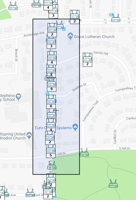
Now you can search WiGLE database for wireless networks by their SSID, (exact value or by mask). Wireless network objects have an attribute with coordinates, so you can place them on map and even create a heatmap.
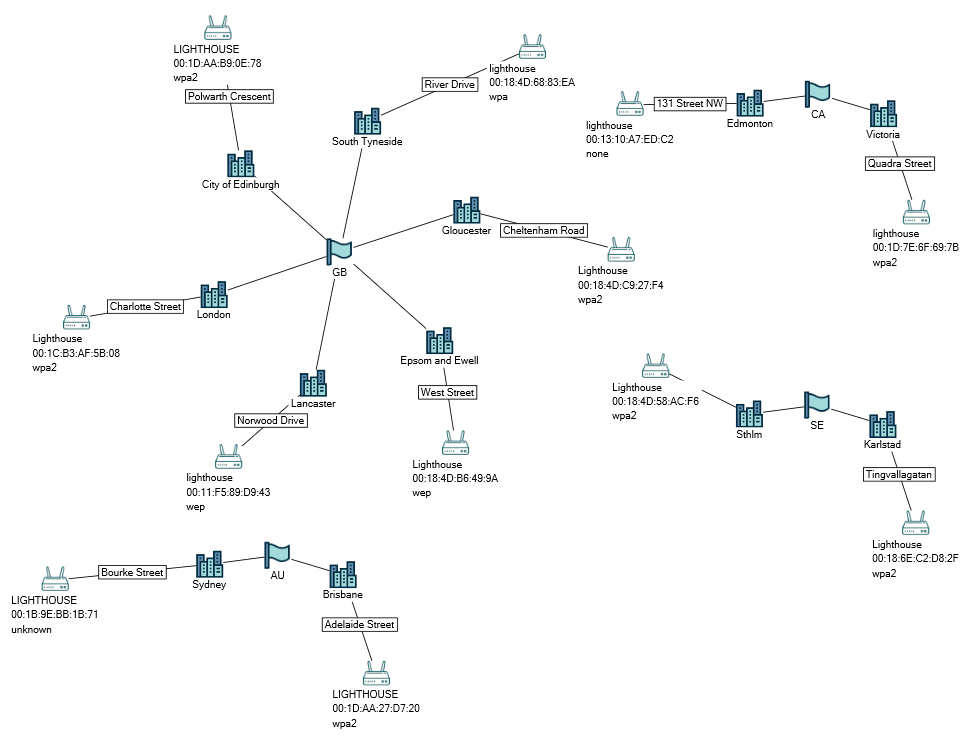
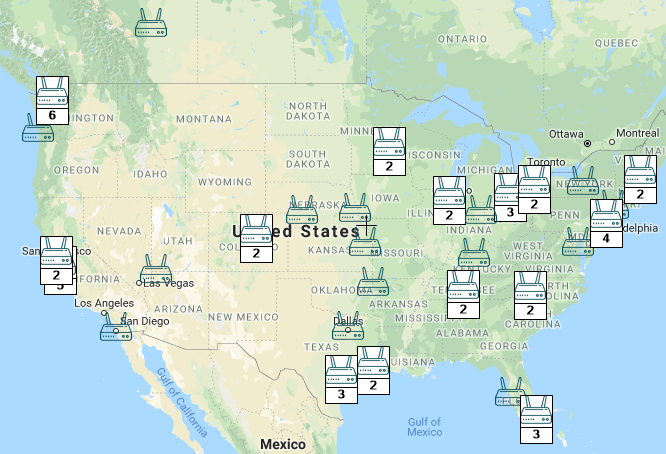
The ‘Area’ enterparam and the GIS macro enable you to search networks right from a map. Select a rectangle on map, right-click it and execute your macro.
It is worth mentioning that WiGLE area search is not very precise, but it is still a good example of how to make geospatial tasks using geojson enterparams.
Icons for custom objects provided by Icons 8